
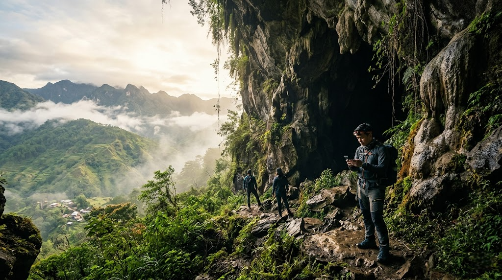
High in the mist-shrouded Cordillera Central mountains, the remote town of Sagada has long been the go-to pilgrimage for travelers seeking bone-chilling mornings, deep subterranean labyrinths, and a slower, soul-cleansing pace. But planning an adventure here in 2026 isn’t just about throwing a sweater into a backpack and hoping for the best.
When you are squeezing through cold, damp crevices in Sumaguing Cave or trekking along the crumbling ridges of Echo Valley, real-time data becomes a safety asset. A sudden tropical depression can transform a dry cave tour into a dangerous, fast-rising aquatic trap within an hour. Here is a definitive, tech-focused tactical guide to mastering the climate tracking, connectivity bottlenecks, and cellular quirks of Sagada.
✓ The Digital Perks
- Town-Center 4G/LTE: Reliable speeds in the main town for uploading footage and managing communication.
- Growing Fiber Footprint: Main homestays and modern cafes now supply stable Wi-Fi connections.
- Microclimate Predictability: High-resolution satellite tracking helps identify exact windows to avoid torrential downpours.
✗ The Technical Realities
- Total Deep Cave Blackouts: Zero cellular signal penetrability once you drop 10 meters inside the limestone networks.
- Topography Dead Zones: Severe terrain shading along deep valleys cuts off cellular towers completely.
- Power Grid Vulnerabilities: Mountain storms frequently cause sudden electricity dropouts, cutting local cell towers down to battery backup.
Subterranean Safety: The Weather Apps You Actually Need
Standard, pre-installed phone weather widgets are notoriously unreliable in the Cordilleras. They aggregate broad regional data, often feeding you conditions for Bontoc or Baguio, completely missing the sudden, highly localized mountain microclimates of Sagada. When exploring caves, an inaccurate forecast can have severe consequences. You need hyper-local radar tracking.
Windy.com App
Switch your layer map to the ECMWF or NEMS models. This allows you to monitor real-time satellite rain accumulation and high-altitude wind directions over Mountain Province.
AccuWeather Premium
Utilize the hyper-localized MinuteCast engine. While it requires active cellular data prior to your trek, it maps out precise precipitation start and stop times over a tight 2-hour window.
PAGASA Radar Web
Bookmark the official state weather portal’s Doppler radar page. Checking the Aparri or Hinatuan radar sweeps gives an unvarnished view of major incoming typhoon systems.
💡 Subterranean Safety Protocol
Never rely solely on software: Limestone is highly porous, and northern cave structures drain entire mountain slopes. Even if an app predicts clear skies, always check in with the local guides at the tourist office. They monitor physical water markers up-mountain that no satellite radar can track.
Signal Analysis: Carrier Performance & Offline Navigation
Do not expect smooth streaming or seamless video calling when winding along mountain passes. Cellular coverage in Sagada is dictating by jagged, vertical terrain that blocks signal transmission. To stay safely oriented, you must prepare your hardware and select the right network before leaving the lowlands.
| Location / Zone | Smart Communications | Globe Telecom | DITO Telecommunity |
|---|---|---|---|
| Poblacion (Town Center) | Strong LTE / Spotty 5G Best for data tasks |
Good LTE / No 5G Consistent messaging |
Unreliable / Intermittent Limited tower footprint |
| Sumaguing & Lumiang Caves | No Signal Drops at mouth |
No Signal Drops at mouth |
No Signal Total blackout |
| Echo Valley & Hanging Coffins | Weak LTE Highly dependent on ridge line |
Weak LTE Fades near valley floor |
Dead Zone Zero service |
| Kiltepan Sunrise Viewpoint | Excellent LTE Great for live streams |
Stable LTE Clean upload bandwidth |
Weak Signal Unstable connection |
Setting Up Your Offline Mapping Ecosystem
Because mobile data is volatile outside the immediate town boundaries, setting up standalone navigation is crucial before setting foot on the trails. Follow this technical preparation routine:
Cache Google Maps Offline
Open Google Maps, search for “Sagada,” swipe up on the bottom menu, and select Download Offline Map. Expand the boundaries to encapsulate Bontoc and Banaue to cover your mountain transport corridors.
Import Vector Trails to Organic Maps or Maps.me
Download Organic Maps (OpenStreetMap engine). Unlike Google, its vector architecture records obscure walking tracks, single-track dirt trails, and precise topography contours around the Marlboro Hills region without requiring network connectivity.
Lock GPS Chips Before Descending
Before starting a trek, open your mapping applications while under clear skies to establish a solid hardware satellite fix. This keeps your location tracking active via direct onboard phone sensors, even when network connectivity drops to zero.
🎒 The Subterranean Tech Packing List
The Optimized Tech-Travel Itinerary
This structural timeline balances intense physical excursions with prime connectivity windows, ensuring you hit natural highlights when atmospheric stability is highest and network congestion is lowest.
Kiltepan Sea of Clouds & Peak Data Upload
The altitude at Kiltepan provides direct line-of-sight to regional transmission infrastructure. This is your premier window for heavy data processing, clearing out cloud backups, or sending rich media files before the rest of the town wakes up and clogs the shared bandwidth pools.
Subterranean Disconnection: Sumaguing Spelunking
Switch your smartphone entirely to Airplane Mode before entry. Leaving cellular search active inside the limestone caves will drain 30% to 40% of your battery in an hour as the internal radio amplifiers cycle at maximum wattage looking for a signal. Protect your device inside an IP68 heavy-duty casing.
Echo Valley Exploration & Central Work Hubs
Trek down to the hanging coffins using your pre-cached offline maps. Once complete, head to the town center to settle into a cafe equipped with local fiber backhauls. Enjoy local mountain coffee while coordinating updates or sorting creative assets.
🎯 Who This Trip Profile Is For
Travelers who value rugged physical adventure but use precise digital preparation to mitigate real-world risks. If you appreciate dramatic mountain topographies and don’t mind unplugging for hours at a time while staying safe with offline tech, this destination is a perfect match.
🛑 Who Should Skip It
Remote workers requiring constant, low-latency video connectivity for live operations or high-throughput enterprise data management. If you feel compromised when lacking multi-carrier 5G backup or dislike damp, enclosed spaces where technology takes a back seat to raw geography, consider staying down-mountain.
📊 Real-World Logistics & Cost Matrix
Note: Ensure your physical currency is in crisp, smaller denominations (₱100 and ₱200 bills). Change can be hard to come by for small vendors and local independent transport providers deep in the valley.
The Definitive Adventure Verdict
Sagada delivers world-class spelunking and pristine alpine beauty, provided you don’t fight the terrain. Treat the technical limitations as a core logistical asset—load your offline databases, pack reliable hardware layers, and rely on indigenous knowledge to manage physical safety parameters.
Disclaimer: Images used in this article are for illustrative purposes only. All photos belong to their respective owners. If you are the copyright holder of any image and wish to request removal or credit update, please contact us.